Oxygen
A Pathway to Making Molecular Oxygen That Doesn’t Involve Life (directly other than the production of the co2?)
So far, life is only known to exist on Earth. But that hasn’t stopped scientists from searching for signs of living creatures on other planets. Those searches intensified with the deployment of the JWST observatory, which astronomers are using to characterize the atmospheres of far-off worlds in the hope of finding the signals of molecules that signify the presence of life (see News Feature: The Skinny on Detecting Life with the JWST). But for that to work, scientists need to know all the possible sources of atmospheric molecules. Now Lucas Sigaud of the Fluminense Federal University, Brazil, and his colleagues have uncovered a pathway for forming an oxygen molecule ( ) from the interaction of a carbon dioxide molecule with an electron [1]. The detailed measurements of the pathway provide key inputs for models used in planetary-life searches.
Molecular oxygen is made on Earth through oxygenic photosynthesis—a process performed by plants, green algae, and cyanobacteria that involves splitting water molecules using sunlight. But molecular oxygen is one of the dominant species in the upper atmospheres of Venus and Mars, planets on which no life has yet been found. So, researchers want to be clear about all the possible ways to create this molecule. “If oxygen [molecules] are to be used as markers in the search for extraterrestrial life, then all the pathways to make them must be known in order to rule out the possibility of erroneous conclusions,” Sigaud says. “We need to find all the puzzle pieces.”
One possible source for atmospheric molecular oxygen is carbon dioxide. For a long time, there were no known routes for directly splitting carbon dioxide into carbon and diatomic oxygen. Then, nearly a decade ago, scientists uncovered a pathway for doing exactly that with photons [2]. In that study, the researchers irradiated carbon dioxide molecules with a high-powered ultraviolet laser showing that they could directly dissociate the carbon and the oxygen molecules, with no intermediate steps. The finding provided a first hint that abiotic sources of molecular oxygen existed. Since then, scientists have posed the possibility that electron interactions with carbon dioxide might also produce molecular oxygen, but the idea remained unconfirmed.
To explore that possibility, Sigaud and his colleagues bombarded a sample of carbon dioxide gas with pulses of electrons with energies ranging from to , a range comparable to that measured for free electrons in Mars’ atmosphere. The pressure of the gas was kept low enough that each electron pulse collided with at most one carbon dioxide molecule. After each electron pulse, an “extraction” field was applied to the system, directing any ions present in the sample toward an ion detector. The detections were then used to determine the cross section—a parameter linked to the likelihood an ion is produced in a particular interaction—of all the resulting charged fragments.
The team’s measurements indicate the electron–carbon dioxide collisions produced (diatomic oxygen that is missing an electron), (carbon that is missing an electron), and (carbon dioxide that is missing two electrons). Sigaud says that the results indicate the following interactions occurred: When an electron passed close enough to a carbon dioxide molecule, there was a transfer of kinetic energy from the electron to the molecule. This energy was sufficient to remove one or two electrons from the neutral molecule, creating an ion. The oxygen and carbon atoms in the ion then changed their positions relative to each other, a process that, in some cases, allowed the carbon atom to split apart from the two oxygen ones. “Electrons act like glue, sticking nuclei together,” Sigaud says. “Remove the glue and lots of things can happen.”
“Molecular oxygen is central to life forming on Earth,” says Raimund Feifel, a physicist at the University of Gothenburg, Sweden, who studies molecular ionization pathways. But he says there is still a lack of knowledge as to how molecular oxygen is produced abiotically and how the concentration of molecular oxygen changes over time. As a case in point, Feifel notes the uncertainty that surrounds the “Great Oxidation Event”—an event 2.4 billion years ago when the concentration of oxygen in the atmosphere suddenly increased and aerobic organisms first appeared. He says the new cross-section data will help in modeling the evolution of planetary atmospheres.
Giada Arney, a planetary scientist at NASA Goddard Space Flight Center, Maryland, agrees agrees that the new observations are important for assessing the origin of oxygen both on Earth and on distant planets. “We don’t want to be fooled by false positives,” she says. “It’s important to understand the abiotic sources and loss processes of when we’re trying to understand it as a biosignature.”
–Katherine Wright
Katherine Wright is the Deputy Editor of Physics Magazine.
Mariana Trench

The Mariana Trench is an oceanic trench located in the western Pacific Ocean, about 200 kilometres (124 mi) east of the Mariana Islands; it is the deepest oceanic trench on Earth. It is crescent-shaped and measures about 2,550 km (1,580 mi) in length and 69 km (43 mi) in width. The maximum known depth is 10,984 ± 25 metres (36,037 ± 82 ft; 6,006 ± 14 fathoms; 6.825 ± 0.016 mi) at the southern end of a small slot-shaped valley in its floor known as the Challenger Deep.[1] The deepest point of the trench is more than 2 km (1.2 mi) farther from sea level than the peak of Mount Everest.[a]
At the bottom of the trench, the water column above exerts a pressure of 1,086 bar (15,750 psi), more than 1,071 times the standard atmospheric pressure at sea level. At this pressure, the density of water is increased by 4.96%.[citation needed] The temperature at the bottom is 1 to 4 °C (34 to 39 °F).[4]
In 2009, the Mariana Trench was established as a US National Monument.[5]
One-celled organisms called monothalamea have been found in the trench at a record depth of 10.6 km (35,000 ft; 6.6 mi) below the sea surface by researchers from Scripps Institution of Oceanography. [6] Data has also suggested that microbial life forms thrive within the trench.[7][8]
Mount Everest
| Mount Everest | |
|---|---|
 | |
| Highest point | |
| Elevation | 8,848.86 m (29,031.7 ft) [note 1] Ranked 1st |
| Prominence | Ranked 1st (Special definition for Everest) |
| Isolation | n/a |
| Listing | |
| Coordinates | 27°59′18″N 86°55′31″E[1] |
| Naming | |
| Etymology | George Everest |
| Native name |
|
| English translation | Holy Mother, Skyhead |
| Geography | |
Location on the border between Koshi Province, Nepal and Tibet Autonomous Region, China | |
| Location | Solukhumbu District, Koshi Province, Nepal;[2] Tingri County, Xigazê, Tibet Autonomous Region, China[note 2] |
| Countries | China and Nepal |
| Parent range | Mahalangur Himal, Himalayas |
| Climbing | |
| First ascent | 29 May 1953 Edmund Hillary and Tenzing Norgay [note 3] Ranked 1st |
| Normal route | Southeast ridge (Nepal) |


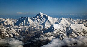
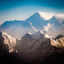
Mount Everest[3] is Earth's highest mountain above sea level, located in the Mahalangur Himal sub-range of the Himalayas. The China–Nepal border runs across its summit point.[4] Its elevation (snow height) of 8,848.86 m (29,031 ft 81⁄2 in) was most recently established in 2020 by the Chinese and Nepali authorities.[5][6]
Mount Everest attracts many climbers, including highly experienced mountaineers. There are two main climbing routes, one approaching the summit from the southeast in Nepal (known as the "standard route") and the other from the north in Tibet. While not posing substantial technical climbing challenges on the standard route, Everest presents dangers such as altitude sickness, weather, and wind, as well as hazards from avalanches and the Khumbu Icefall. As of May 2024, 340 people have died on Everest. Over 200 bodies remain on the mountain and have not been removed due to the dangerous conditions.[7][8]
The first recorded efforts to reach Everest's summit were made by British mountaineers. As Nepal did not allow foreigners to enter the country at the time, the British made several attempts on the north ridge route from the Tibetan side. After the first reconnaissance expedition by the British in 1921 reached 7,000 m (22,970 ft) on the North Col, the 1922 expedition pushed the north ridge route up to 8,320 m (27,300 ft), marking the first time a human had climbed above 8,000 m (26,247 ft). The 1924 expedition resulted in one of the greatest mysteries on Everest to this day: George Mallory and Andrew Irvine made a final summit attempt on 8 June but never returned, sparking debate as to whether they were the first to reach the top. Tenzing Norgay and Edmund Hillary made the first documented ascent of Everest in 1953, using the southeast ridge route. Norgay had reached 8,595 m (28,199 ft) the previous year as a member of the 1952 Swiss expedition. The Chinese mountaineering team of Wang Fuzhou, Gonpo, and Qu Yinhua made the first reported ascent of the peak from the north ridge on 25 May 1960.[9]
Name

Mount Everest's Nepali/Sanskrit name is Sagarmāthā (IAST transcription) or Sagar-Matha[10] (सगर-माथा, [sʌɡʌrmatʰa], lit. "goddess of the sky"[11]),[12] which means "the head in the great blue sky", being derived from सगर (sagar), meaning "sky", and माथा (māthā), meaning "head".[13]
The Tibetan name for Everest is Qomolangma (ཇོ་མོ་གླང་མ, lit. "holy mother"). The name was first recorded (in a Chinese transcription) in the 1721 Kangxi Atlas, issued during the reign of Qing Emperor Kangxi; it first appeared in the West in 1733 as Tchoumour Lancma, on a map prepared by the French geographer D'Anville and based on Kangxi Atlas.[14] The Tibetan name is also popularly romanised as Chomolungma and (in Wylie) as Jo-mo-glang-ma.[19]
The official Chinese transcription is 珠穆朗玛峰 (t 珠穆朗瑪峰), or Zhūmùlǎngmǎ Fēng in pinyin. While other Chinese names have been used historically, including Shèngmǔ Fēng (t 聖母峰, s 圣母峰, lit. "holy mother peak"), these names were largely phased out after the Chinese Ministry of Internal Affairs issued a decree to adopt a sole name in May 1952.[20]
The British geographic survey of 1849 attempted to preserve local names when possible (e.g., Kangchenjunga and Dhaulagiri.) However, Andrew Waugh, the British Surveyor General of India, claimed that he could not find a commonly used local name, and that his search for one had been hampered by the Nepalese and Tibetan policy of exclusion of foreigners. Waugh argued that - because there were many local names - it would be difficult to favour one name over all others; he therefore decided that Peak XV should be named after British surveyor Sir George Everest, his predecessor as Surveyor General of India.[21][22][23] Everest himself opposed the honor, and told the Royal Geographical Society in 1857 that "Everest" could neither be written in Hindi nor pronounced by "the native of India". Despite Everest's objections, Waugh's proposed name prevailed, and the Royal Geographical Society officially adopted the name "Mount Everest" in 1865.[21][24] The modern pronunciation of Everest (/ˈɛvərɪst/)[25] is different from Sir George's pronunciation of his surname (/ˈiːvrɪst/ EEV-rist).[26]
In the late 19th century, many European cartographers incorrectly believed that a native name for the mountain was Gaurishankar, a mountain between Kathmandu and Everest.[27]
Lechatelierite
| Lechatelierite | |
|---|---|
 Lechatelierite created by a high voltage power line arcing on rocky soil | |
| General | |
| Category | Oxides |
| Formula (repeating unit) | SiO2 |
| IMA symbol | Lch[1] |
| Strunz classification | 4/D.01-10 |
| Dana classification | 75.0.0.0 |
| Crystal system | Amorphous |
| Identification | |
| Formula mass | 60.08 gm |
| Colour | Colourless, white |
| Crystal habit | Porcelainous |
| Cleavage | None |
| Fracture | Conchoidal |
| Mohs scale hardness | 6.5 |
| Luster | Vitreous |
| Streak | White |
| Diaphaneity | Translucent |
| Density | 2.5–2.65 |
Lechatelierite is silica glass, amorphous SiO2, non-crystalline mineraloid. It is named for Henry Louis Le Chatelier.
Structure[edit]
Lechatelierite is a mineraloid as it does not have a crystal structure. Although not a true mineral, it is often classified in the quartz mineral group.
Formation[edit]
One common way in which lechatelierite forms naturally is by very high temperature melting of quartz sand during a lightning strike. The result is an irregular, branching, often foamy hollow tube of silica glass called a fulgurite.[2] Not all fulgurites are lechatelierite; the original sand must be nearly pure silica.
Lechatelierite also forms as the result of high pressure shock metamorphism during meteorite impact cratering and is a common component of a type of glassy ejecta called tektites. Most tektites are blobs of impure glassy material, but tektites from the Sahara Desert in Libya and Egypt, known as Libyan desert glass, are composed of almost pure silica that is almost pure lechatelierite.[3] High pressure experiments have shown that shock pressures of 85 GPa are needed to produce lechatelierite in quartz grains embedded in granite.[4]
Lechatelierite was formed during the impact of a meteorite into a layer of Coconino Sandstone at Meteor Crater in Arizona. During the rapid pressure reduction following the impact, steam expanded the newly formed lechatelierite. The shattered and expanded glass has a density less than that of water.[5]
Lechatelierite may also form artificially, a unique example being the trinitite produced by melting of quartz sand at the first nuclear bomb explosion at Trinity Flats, White Sands, New Mexico.[6]
Fulgurite

| Stereo image | |||
|---|---|---|---|
| |||
| |||
| |||
| |||
| Two Type I (arenaceous) fulgurites: a section of a common tube fulgurite and one exhibiting a branch | |||
| Stereo image | |||
|---|---|---|---|
| |||
| |||
| |||
| |||
| Two small Type I Saharan Desert fulgurites.[1] In a planar view the specimen on the right has a blade-like morphology, but its tubular nature is dramatically shown in a stereo view. | |||

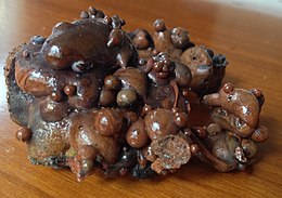
Fulgurites (from Latin fulgur 'lightning', and -ite), commonly called "fossilized lightning", are natural tubes, clumps, or masses of sintered, vitrified, or fused soil, sand, rock, organic debris and other sediments that sometimes form when lightning discharges into ground. When composed of silica, fulgurites are classified as a variety of the mineraloid lechatelierite.
When ordinary negative polarity cloud-ground lightning discharges into a grounding substrate, greater than 100 million volts (100 MV) of potential difference may be bridged.[2] Such current may propagate into silica-rich quartzose sand, mixed soil, clay, or other sediments, rapidly vaporizing and melting resistant materials within such a common dissipation regime.[3] This results in the formation of generally hollow and/or vesicular, branching assemblages of glassy tubes, crusts, and clumped masses.[4] Fulgurites have no fixed composition because their chemical composition is determined by the physical and chemical properties of whatever material is being struck by lightning.
Fulgurites are structurally similar to Lichtenberg figures, which are the branching patterns produced on surfaces of insulators during dielectric breakdown by high-voltage discharges, such as lightning.[5][6]
Description[edit]
Fulgurites are formed when lightning strikes the ground, fusing and vitrifying mineral grains.[7] The primary SiO2 phase in common tube fulgurites is lechatelierite, an amorphous silica glass. Many fulgurites show some evidence of crystallization: in addition to glasses, many are partially protocrystalline or microcrystalline. Because fulgurites are generally amorphous in structure, fulgurites are classified as mineraloids.
Material properties (size, color, texture) of fulgurites vary widely, depending on the size of the lightning bolt and composition and moisture content of the surface struck by lightning. Most natural fulgurites fall on a spectrum from white to black. Iron is a common impurity that can result in a deep brownish-green coloration. Lechatelierite similar to fulgurites can also be produced via controlled (or uncontrolled) arcing of artificial electricity into a medium. Downed high voltage power lines have produced brightly colored lechatelierites, due to the incorporation of copper or other materials from the power lines themselves.[8] Brightly colored lechatelierites resembling fulgurites are usually synthetic and reflect the incorporation of synthetic materials. However, lightning can strike man-made objects, resulting in colored fulgurites.
The interior of Type I (sand) fulgurites normally is smooth or lined with fine bubbles, while their exteriors are coated with rough sedimentary particles or small rocks. Other types of fulgurites are usually vesicular, and may lack an open central tube; their exteriors can be porous or smooth. Branching fulgurites display fractal-like self-similarity and structural scale invariance as a macroscopic or microscopic network of root-like branches, and can display this texture without central channels or obvious divergence from morphology of context or target (e.g. sheet-like melt, rock fulgurites). Fulgurites are usually fragile, making the field collection of large specimens difficult.
Fulgurites can exceed 20 centimeters in diameter and can penetrate deep into the subsoil, sometimes occurring as far as 15 m (49 ft) below the surface that was struck,[9] although they may also form directly on a sedimentary surface.[10] One of the longest fulgurites to have been found in modern times was a little over 4.9 m (16 ft) in length, and was found in northern Florida.[11] The Yale University Peabody Museum of Natural History displays one of the longest known preserved fulgurites, approximately 4 m (13 ft) in length.[12] Charles Darwin in The Voyage of the Beagle recorded that tubes such as these found in Drigg, Cumberland, UK reached a length of 9.1 m (30 ft).[13][14] The Winans Lake fulgurite[s] (Winans Lake, Livingston County, Michigan), extended discontinuously throughout a 30 m range, and arguably includes the largest reported fulgurite mass ever recovered and described: its largest section extending approximately 16 ft (4.88 m) in length by 1 ft in diameter (30 cm).[4][15]
Peak temperatures within a lightning channel exceed 30,000 K, with sufficient pressure to produce planar deformation features in SiO2, a kind of polymorphism. This is also known colloquially as shocked quartz.[16]


Comments
Post a Comment
No Comment